Columnar pines
Tall narrow Araucaria trees create the island's unmistakable skyline above bays and forest.
Plan the least frequent boat, ferry or exposed coastal section first. Use early or late light and keep a weather alternative during Apr-Nov.
Columnar pines, bright lagoon water, limestone caves and Kanak communities give a small Melanesian island a distinctive silhouette.
Tall narrow Araucaria trees create the island's unmistakable skyline above bays and forest.
Plan the least frequent boat, ferry or exposed coastal section first. Use early or late light and keep a weather alternative during Apr-Nov.
The details that make Isle of Pines different.
Tall narrow Araucaria trees create the island's unmistakable skyline above bays and forest.
A protected natural pool and reef channels reveal the clarity and structure of the lagoon.
Customary land, villages and historical layers give the island identity beyond its beaches.
Columnar pines, bright lagoon water, limestone caves and Kanak communities give a small Melanesian island a distinctive silhouette. This account follows the forces, communities and decisions that made the present landscape.
The Isle of Pines, known locally as Kunie, lies south of New Caledonia's main island. Tall Araucaria columnaris trees rise above white beaches and turquoise bays, creating a visual combination unlike a typical tropical island. Low limestone terrain, forest and reef complete the landscape.
Many visits to Isle of Pines begin with the experience described as “Columnar pines”. The more revealing question is why it exists here, how people used the surrounding ground and what remains visible from earlier phases. Tall narrow Araucaria trees create the island's unmistakable skyline above bays and forest.
Continue to practical planningThe first layer of Isle of Pines is geological and ecological rather than scenic. Oro and Kuto bays show different lagoon forms, from sheltered natural pools to broad beach arcs. Caves and uplifted coral limestone add an inland dimension. The surrounding reef protects large areas of calm water while open ocean remains close beyond it.
Routes and settlements at Isle of Pines follow the water system even when the map emphasises roads. “Columnar pines” exposes that older logic. Tall narrow Araucaria trees create the island's unmistakable skyline above bays and forest.
At Isle of Pines, human history is written into settlement and land use rather than separated from the scenery. Kanak communities and customary authorities shape land use and access. Mission history, a former penal colony and contemporary tourism add complex layers to the island. The French name records one visual feature, but the cultural identity of Kunie is broader and older.
The role of “Oro Bay” is especially revealing at Isle of Pines. A protected natural pool and reef channels reveal the clarity and structure of the lagoon. In the history of Isle of Pines, it connects the wider regional context with a specific place that can still be examined today.
The decisive modern change at Isle of Pines was access. At Isle of Pines, transport and visitor infrastructure made the landscape easier to reach while concentrating pressure at the few points where roads, boats or trails enter it. At Isle of Pines, that transition remains visible in the contrast between older working features and visitor infrastructure.
At Isle of Pines, the significance of the feature “Columnar pines” goes beyond its visual impact. Tall narrow Araucaria trees create the island's unmistakable skyline above bays and forest. Within Isle of Pines, the feature explains why this destination differs from nearby landscapes.
At Isle of Pines, the significance of the feature “Oro Bay” goes beyond its visual impact. A protected natural pool and reef channels reveal the clarity and structure of the lagoon. At Isle of Pines, the detail links local scale with the wider regional pattern.
At Isle of Pines, the feature “Kunie cultural landscape” provides a precise clue to how the landscape works. Customary land, villages and historical layers give the island identity beyond its beaches. Within Isle of Pines, the feature explains why this destination differs from nearby landscapes.
At Isle of Pines, season is part of the landscape history, not merely a planning detail. The cooler dry season generally brings comfortable conditions and clearer lagoon water. Summer is warmer, wetter and carries cyclone risk. Trade winds and tides continue to shape coastal conditions throughout the year.
For Isle of Pines, the main seasonal constraint is: the strongest planning window is Apr-Nov. For Isle of Pines, outside it, check weather, daylight, road or ferry schedules and seasonal closures before committing to a fixed route.
For Isle of Pines, one practical detail matters: wind, sea state and tide can matter as much as distance. For Isle of Pines, check conditions before boat trips, exposed cliffs or tidal sections.
Placed within its wider geography, Isle of Pines is not an isolated exception. For Isle of Pines, the wider context shows that, the island belongs to the New Caledonian lagoon system and shares ecological relationships with Grande Terre and the Loyalty Islands. For Isle of Pines, its endemic flora and reef environment place it within a globally distinctive southwest Pacific region.

A narrow raised-coral island separates a brilliant lagoon from the open Pacific along one of the region's longest beaches.
Explore this place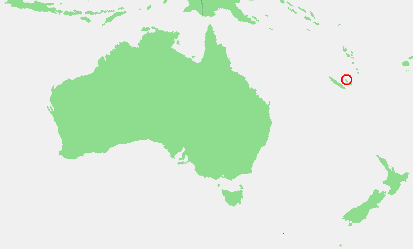
A raised coral island of high cliffs, deep caves, vanilla gardens and Kanak communities east of New Caledonia's main island.
Explore this place
A volcanic main island and a wide turquoise lagoon are enclosed by reef and small motu in the central South Pacific.
Explore this place